SNOHOMISH COUNTY—The National Weather Service has issued a Blizzard Warning for the Cascades and areas above 2,000 feet starting 4 a.m., Tuesday, to Wednesday, January 10. Expect lots of rain in lowland areas from 4 a.m., January 8, to Tuesday, January 9.
“It’s very rare for an actual blizzard warning to be issued,” WA Emergency Management posted on X. “This is not a good time to be traveling the passes. If you can avoid travel, please do so.”


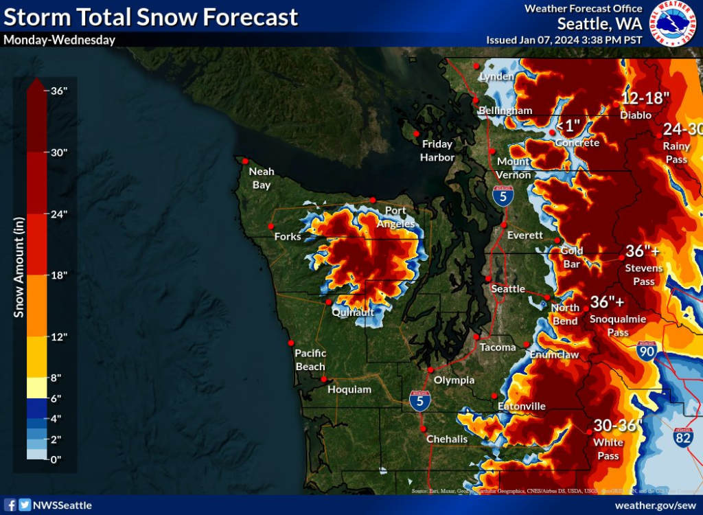
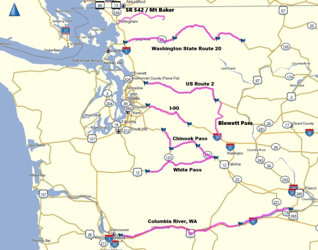
The heaviest snow is expected for Tuesday. Travelers are asked to routinely check WSDOT’s real-time travel data for the latest pass conditions and alerts.
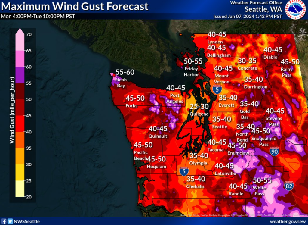
NWS Seattle warns of a strong chance of power outages and downed trees as “peak wind gusts will range from 35 to 45 m.p.h. around much of the region”—a week tropical storm strength. A round of southerly winds will develop across the area late Monday night, then a strong push of west/southwest winds will follow on Tuesday.

NWS Seattle reports for evening Sunday, expect widespread rain. Lowland rain and mountain snow on Monday with a possibility of a brief rain/snow mix north of Everett in the morning.


Active Weather:
An active pattern is expected next week. A stronger system will move across the area Monday-Tuesday for generally lowland rain, heavy mountain snow, & stronger winds. Uncertainty increases in the forecast Thursday onward, but a colder pattern is expected. #wawx pic.twitter.com/Ac13EAYaDL
— NWS Seattle (@NWSSeattle) January 7, 2024
For Tuesday, expect the continuation of rain in lowland areas with snow in the mountains through Thursday morning. Heavy snow is expected in the Cascade Passes with windy conditions across Western Washington.
Temperatures are expected to cool Thursday and into next weekend. Better predictions for the possibility of snow after Thursday is expected within the coming days.
Snohomish County Weather Outlook for the Week of January 8, 2024
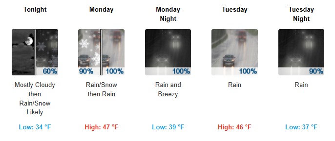
Sunday Evening, Jan 7: Rain and snow likely, mainly after 5am. Mostly cloudy, with a low around 34. Southeast wind 3 to 6 mph. Chance of precipitation is 60%. Little or no snow accumulation expected.
Monday, January 8: Rain and snow likely before 7am, then rain. High near 47. Southeast wind around 9 mph. Chance of precipitation is 100%. Little or no snow accumulation expected.
Monday Night
Rain. Low around 39. Breezy, with a south wind 11 to 16 mph increasing to 20 to 25 mph after midnight. Winds could gust as high as 39 mph. Chance of precipitation is 100%. New precipitation amounts between a quarter and half of an inch possible.
Tuesday, January 9: Rain. High near 46. South southwest wind around 16 mph, with gusts as high as 24 mph. Chance of precipitation is 100%. New precipitation amounts between a tenth and quarter of an inch possible.
Tuesday Night
Rain. Low around 37. South southwest wind 11 to 14 mph, with gusts as high as 20 mph. Chance of precipitation is 90%. New precipitation amounts between a tenth and quarter of an inch possible.
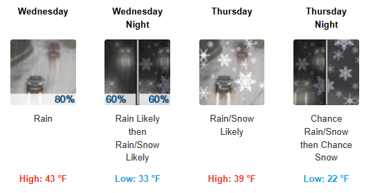
Wednesday, January 10: Rain. High near 43. Chance of precipitation is 80%. New precipitation amounts between a tenth and quarter of an inch possible.
Wednesday Night
Rain likely before 1am, then rain and snow likely. Mostly cloudy, with a low around 33. Chance of precipitation is 60%. Little or no snow accumulation expected.
Thursday, January 11: Snow likely, possibly mixed with rain. Mostly cloudy, with a high near 39.
Thursday Night
A chance of rain and snow before 10pm, then a chance of snow. Mostly cloudy, with a low around 22.
Friday, January 12: A chance of rain and snow. Partly sunny, with a high near 31.
Friday Night
A chance of rain and snow. Mostly cloudy, with a low around 23.
Saturday, January 13: A chance of rain and snow. Partly sunny, with a high near 32.
Saturday Night
A chance of rain and snow. Mostly cloudy, with a low around 23.
Sunday, January 14: A chance of rain and snow. Partly sunny, with a high near 33.
Active weather ahead through the week for Western Washington, here's a sneak peek behind the scenes at the office. We'll be providing additional forecast updates this afternoon! #WAwx pic.twitter.com/AwgdkRcPWX
— NWS Seattle (@NWSSeattle) January 7, 2024
Lynnwood Times Weather Tips
Prepare for icy commutes. Stay off of the roads if you can. If you must travel, check WSDOT’s Traffic twitter account (https://twitter.com/wsdot_traffic) for current conditions on I-5, I-405 and our state highways. The Sheriff’s Office will be posting local road closures to their twitter account as well (https://twitter.com/SnoCoSheriff).
Prepare to be without electricity. #TeamPUD crews will continue to restore power to customers as quickly as conditions allow. The PUD prioritizes outages from big to small, focusing on the higher-voltage transmission level that power substations with large customers like hospitals, schools and businesses. Next, are main circuits from substations that serve neighborhoods and businesses. Finally, smaller outages that serve a handful of homes are addressed. Don’t call 911 if you lose power. Report outages to 425-783-1001 or outagemap.snopud.com.
Heat your home safely. Beware carbon monoxide. Never try to heat your home using a gas stove or charcoal grill. Run portable generators in a well-vented outside area. If your power is out, designate a warmer area in your home as a primary living area, preferably with fewer windows. Dress in layers and, if needed, with a scarf, gloves and hat.
Need a place to stay? With below-freezing temperatures forecast this week, we expect an increased demand for cold weather shelter. Multiple locations in Snohomish County provide overnight shelter when temperatures are below 32 degrees F. Coordinators and volunteers work hard to meet the need in the community, but space is limited. If you are in need of shelter, please call 211 or call ahead to a cold weather shelter. Additional information, including a list of local shelters indicating which are open, is available at www.snohd.org/cold.
Snohomish County road crews at work. Remember to give snowplows and deicers plenty of room this evening. Allow a minimum following distance of 200 feet from plows and deicers while they work. If you must pass, take extreme caution and beware of the displaced snow and ice, or sand spray.
Help each other. Keep an eye on your kids and pets if you are outside, especially near any ponds, lakes or rivers. Check on your elderly or home-bound neighbors.
Stay safe. If you must go out talk over your travel plans with others in your home, even if the trip is just a few miles. Be sure to wear extra layers of outerwear if you will be outside for any length of time (jackets, hats, gloves, extra socks, etc.)

Author: Lynnwood Times Staff