SNOHOMISH COUNTY—Bundle up and stay warm this weekend as temperatures are predicted to drop well below freezing throughout Snohomish County starting Thursday night lasting until Tuesday morning. Up to two inches of snow is forecast for Friday night to Saturday morning.
A colder airmass will continue to settle across W. WA that will help increase snowfall chances Thu-Sat, though considerable uncertainty remains in the track of a surface low Sat. Here are possible forecast snowfall ranges.#WAwx pic.twitter.com/xWilTW5FRB
— NWS Seattle (@NWSSeattle) January 10, 2024


The National Weather Service (NWS) has issued a Coastal Flood Advisory along the shoreline and low-lying coastal areas from Skagit County to Seattle until 3 p.m., Wednesday, January 10. The advisory warns of minor coastal flooding due to tidal overflow that may lead to flooding of parking lots, parks, and roads.
Residents of Snohomish County should expect up to a half an inch of rain until Thursday morning that will transition into a wintery mix of snow/rain by Thursday night. No rain is forecasted for Friday but freezing conditions are expected with temperatures plummeting to highs and lows in the mid-twenties. Up to two inches of snow is forecast for Friday night to Saturday morning.


On a positive note, air quality is forecasted to be good throughout the weekend and winds will be mild between 5 to 10 miles per hour.
#Blizzard warning up at Stevens Pass! Conditions rapidly were deteriorating after we got there, and continued to once we left. This is not even the peak of the storm, with wind expected to increase more through the day. #wawx #snow pic.twitter.com/JFjwNLEhSQ
— Benjamin Jurkovich (@BenJurkovichWX) January 9, 2024


Winter Storm Gerri delivered blizzard conditions to the Cascades areas on Tuesday with up to 29 inches of snow, according to The Weather Channel. WSDOT reports US 2 Stevens Pass is closed from MP 58 (Scenic) to MP 80, (five miles west of Coles Corner) due to poor visibility, high winds and heavy snow. No detours available and no estimated time of reopening. US 97 Blewett Pass will also remain closed. WSDOT will be reevaluating conditions early Wednesday morning (January 10). Gerri is on its way to the Central US.
Travelers are asked to routinely check WSDOT’s real-time travel data for the latest pass conditions and alerts.
Snohomish County Weather Outlook January 10 to 16
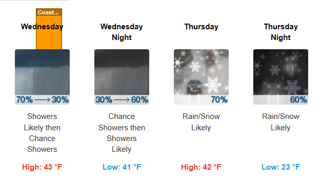
Wednesday, January 10: Showers likely, mainly before 1pm. Mostly cloudy, with a high near 43. Light and variable wind becoming west southwest around 5 mph. Chance of precipitation is 70%. New precipitation amounts between a tenth and quarter of an inch possible.
Wednesday Night
Showers likely, mainly after 1am. Mostly cloudy, with a steady temperature around 41. Southwest wind 3 to 7 mph. Chance of precipitation is 60%. New precipitation amounts of less than a tenth of an inch possible.
Thursday, January 11: Rain and snow showers likely. Mostly cloudy, with a high near 42. West northwest wind 9 to 11 mph. Chance of precipitation is 70%. Little or no snow accumulation expected.
Thursday Night
Rain and snow showers likely before 1am, then a chance of snow showers. Mostly cloudy, with a low around 23. North northwest wind around 9 mph. Chance of precipitation is 60%. New snow accumulation of less than a half inch possible.
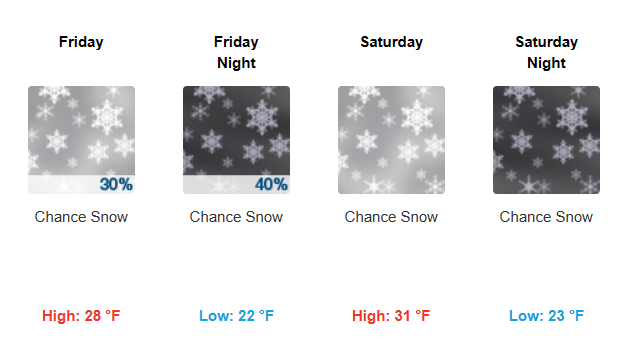
Friday, January 12: A 30 percent chance of snow. Partly sunny, with a high near 28. New snow accumulation of less than one inch possible.
Friday Night
A 40 percent chance of snow. Mostly cloudy, with a low around 22. New snow accumulation of 1 to 2 inches possible.
Saturday, January 13: A chance of snow. Partly sunny, with a high near 31.
Saturday Night
A chance of snow, mainly before 10pm. Mostly cloudy, with a low around 23.
Sunday, January 14: A slight chance of snow. Partly sunny, with a high near 34.
Sunday Night
A slight chance of snow. Mostly cloudy, with a low around 23.
M.L.King Day, January 15: Partly sunny, with a high near 35.
Monday Night
A slight chance of snow. Mostly cloudy, with a low around 26.
Tuesday, January 16: A chance of rain and snow. Partly sunny, with a high near 39.
Lynnwood Times Weather Tips
Prepare for icy commutes. Stay off of the roads if you can. If you must travel, check WSDOT’s Traffic twitter account (https://twitter.com/wsdot_traffic) for current conditions on I-5, I-405 and our state highways. The Sheriff’s Office will be posting local road closures to their twitter account as well (https://twitter.com/SnoCoSheriff).
Prepare to be without electricity. #TeamPUD crews will continue to restore power to customers as quickly as conditions allow. The PUD prioritizes outages from big to small, focusing on the higher-voltage transmission level that power substations with large customers like hospitals, schools and businesses. Next, are main circuits from substations that serve neighborhoods and businesses. Finally, smaller outages that serve a handful of homes are addressed. Don’t call 911 if you lose power. Report outages to 425-783-1001 or outagemap.snopud.com.
Heat your home safely. Beware carbon monoxide. Never try to heat your home using a gas stove or charcoal grill. Run portable generators in a well-vented outside area. If your power is out, designate a warmer area in your home as a primary living area, preferably with fewer windows. Dress in layers and, if needed, with a scarf, gloves and hat.
Need a place to stay? With below-freezing temperatures forecast this week, we expect an increased demand for cold weather shelter. Multiple locations in Snohomish County provide overnight shelter when temperatures are below 32 degrees F. Coordinators and volunteers work hard to meet the need in the community, but space is limited. If you are in need of shelter, please call 211 or call ahead to a cold weather shelter. Additional information, including a list of local shelters indicating which are open, is available at www.snohd.org/cold.
Snohomish County road crews at work. Remember to give snowplows and deicers plenty of room this evening. Allow a minimum following distance of 200 feet from plows and deicers while they work. If you must pass, take extreme caution and beware of the displaced snow and ice, or sand spray.
Help each other. Keep an eye on your kids and pets if you are outside, especially near any ponds, lakes or rivers. Check on your elderly or home-bound neighbors.
Stay safe. If you must go out talk over your travel plans with others in your home, even if the trip is just a few miles. Be sure to wear extra layers of outerwear if you will be outside for any length of time (jackets, hats, gloves, extra socks, etc.)

Author: Mario Lotmore