SNOHOMISH COUNTY—A countywide state of emergency has been declared, with the Washington State Emergency Operations Center at its highest activation level and National Guard resources deployed for support.

All major rivers in the county – Snohomish, Skykomish, Stillaguamish, and portions of the Skagit – are at major flood stages as of Thursday (Dec. 11) morning and approaching record levels, posing severe threats to life, property, homes, roads, and critical infrastructure.
A flood watch is when flooding is possible; a flood warning is when flooding is happening or about to happen.
Current River Status Summary (as of December 11, 2025 morning observations):


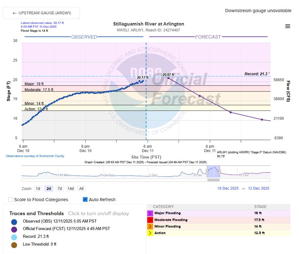
⚠Stillaguamish River near City of Arlington
• Latest observed: 19.79 ft (5:40 a.m., Dec 11)
• 24-hour forecast (10 a.m., Dec 12): 9.03 ft, forecasted to peak at 20.87 ft by 10 a.m., Dec 11.
• Flood stage: 14 ft
• Current Status: Flood Warning – Severe/Near-Record Major Flooding (Phase 4)
⚠North Fork Stillaguamish River near City of Arlington
• Latest observed: 14.9 ft (5:15 a.m., Dec 11)
• 24-hour forecast (10 a.m., Dec 12): 9.57 ft
• Flood stage: 13 ft
• Current Status: Flood Warning – Severe/Near-Record Major Flooding (Phase 4)


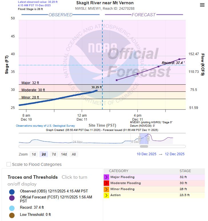
⚠Skagit River near City of Mt Vernon (may impact Northern parts of Snohomish County)
• Latest observed: 30.56 ft (5:15 a.m., Dec 11)
• 24-hour forecast (10 a.m., Dec 12): 39.29 ft
• Flood stage: 28 ft
• Current Status: Flood Warning – Severe/Near-Record Major Flooding (Phase 4)
⚠South Fork Stillaguamish River near Jordan River Rd. Bridge
• Latest observed: 210.92 ft (5:30 a.m., Dec 11)
• 24-hour forecast (10 a.m., Dec 12): 210.30 ft
• Flood stage: 211 ft
• Current Status: Flood Warning – Severe/Near-Record Major Flooding (Phase 4)
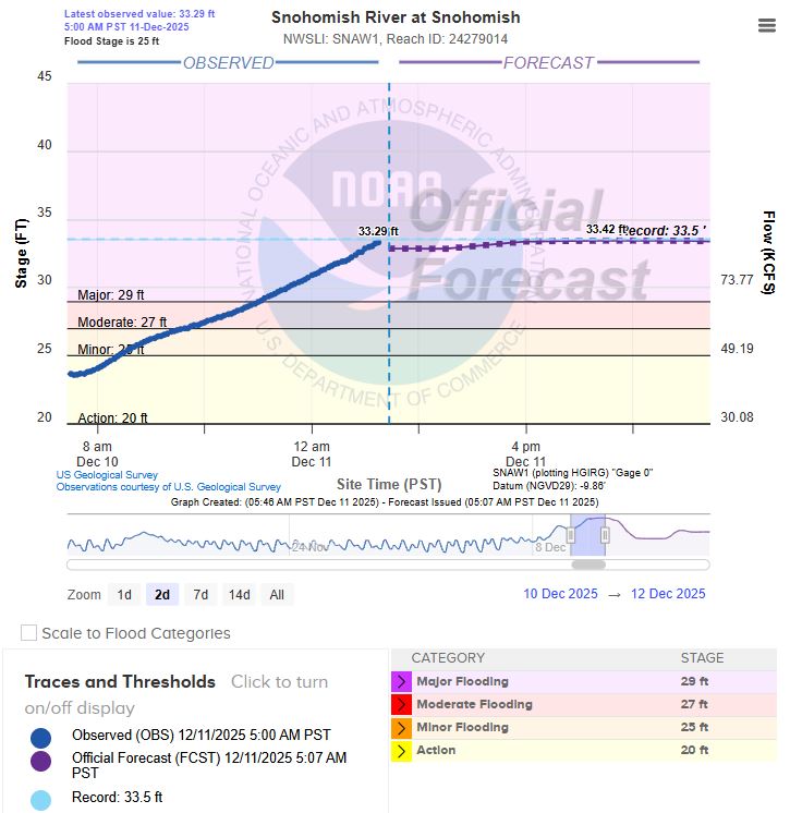
⚠Snohomish River near City of Snohomish
• Latest observed: 33.29 ft (5 a.m., Dec 11)
• 24-hour forecast (10 a.m., Dec 12): 33.23 ft (near-record crest)
• Flood stage: 25 ft
• Current Status: Flood Warning – Severe/Near-Record Major Flooding (Phase 4)
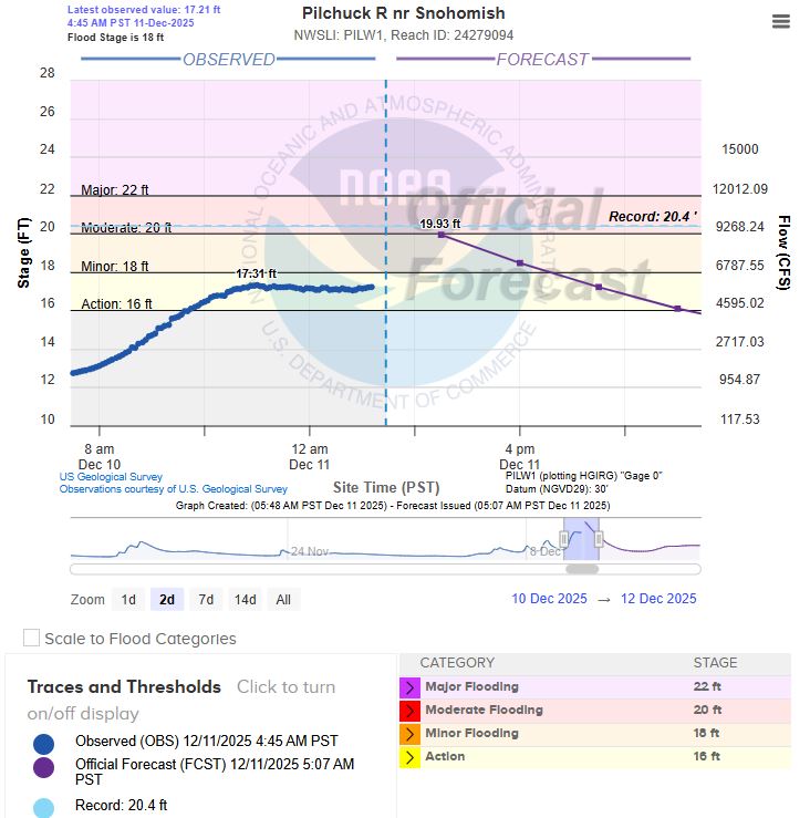
⚠Pilchuck River near City of Snohomish
• Latest observed: 17.21 ft (4:45 a.m., Dec 11)
• 24-hour forecast (10 a.m., Dec 12): 14.63 ft, forecasted to peak at 18.15 ft by 10 a.m., Dec 11.
• Flood stage: 18 ft
• Current Status: Flood Action – Preparation for possible flooding.
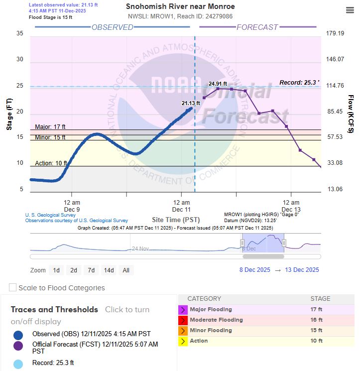
⚠Snohomish River near City of Monroe
• Latest observed: 22.01 ft (5:15 a.m., Dec 11)
• 24-hour forecast (10 a.m., Dec 12): 20.16 ft, forecasted to peak at 24.91 ft by 4 p.m., Dec 11.
• Flood stage: 15 ft
• Current Status: Flood Warning – Severe/Near-Record Major Flooding (Phase 4)
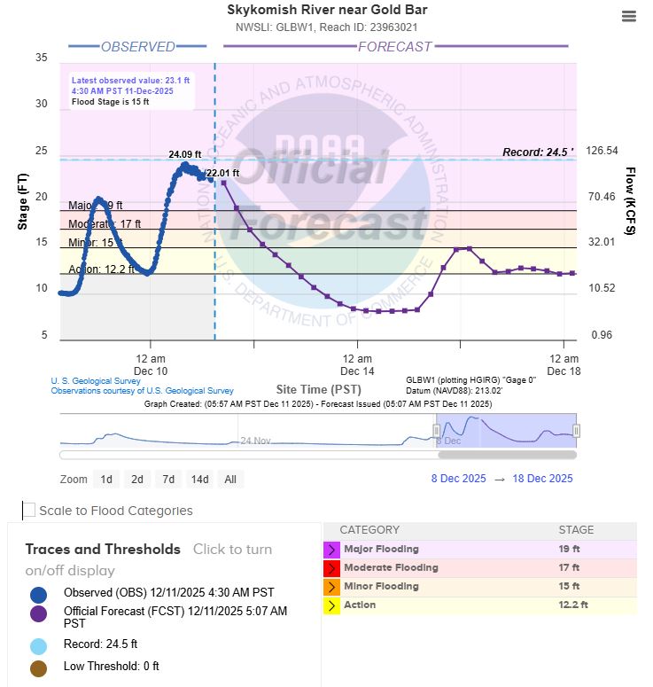
⚠Skykomish River near City of Gold Bar
• Latest observed: 22.64 ft (5:30 a.m., Dec 11)
• 24-hour forecast (10 a.m., Dec 12): 14.23 ft
• Flood stage: 15 ft
• Current Status: Flood Warning – Severe/Near-Record Major Flooding (Phase 4)
Current Road Closures in Snohomish County (as of December 11, 2025)
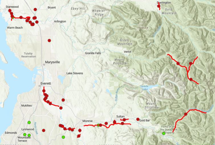
Dozens of roads are closed throughout Snohomish County due to overnight flooding. If you come across a flooded roadway: remember, turn around, don’t drown! Floodwater is often much deeper than they appear.
- Expect Detours: Anticipate detours near flood-prone areas.
- Follow posted signage and allow extra travel time.
- NEVER drive through standing water.
- When road is flooded turn around!
Check the Snohomish County Road Closure map for road closure updates: https://bit.ly/SnoCoRoadsClosedMap
Current Evacuations in Snohomish County (as of December 11, 2025)
⚠Level 3 Evacuations (Immediate—Leave Now):
- Ebey Island and low-lying areas west of Sunnyside Blvd. (dikes overtopped midday December 10; do not return for several days).
- Low-lying homes in Tualco Valley (flooding overnight; roads inundated).
- Sultan: Residents south of Date Street and west of 4th Street (conditions worsening; emergency shelter at Evergreen State Fairgrounds in Monroe).
- Areas near Mann Road in Sultan (multiple residents rescued by helicopter December 10; homes trapped by floodwaters).
- Flood-prone zones along the Stillaguamish River near Arlington (record crest expected ~24 ft; homes and roads flooding).
- Three Rivers Mobile Homes.
⚠Level 2 Evacuations (Set—Prepare to Leave Within Hours):
- Areas near Monroe, Gold Bar, and downstream river valleys along the Skykomish River (major flooding; widespread inundation).
- Portions of northwestern Snohomish County along the Skagit River (catastrophic major flooding; potential levee failure; impacts from Skagit County upstream).

Author: Mario Lotmore