WASHINGTON STATE—Meteorologists working with the National Weather Service (NWS) issued weather alerts for Washington residents on Wednesday, December 10, due to, what they’re predicting to be, “record-breaking flooding” – especially in the Puget Sound and Northern Cascades regions.

In response, Washington Governor Bob Ferguson signed an emergency proclamation in anticipation of these floods throughout the Puget Sound, North Cascade, and low-lying river basins in the eastern side of the state – including near Burlington, Mount Vernon, Sedro Wooley, Lyman, Concrete, and Hamilton.


“This allows us to seek federal funds to cover the cost of this response, which we anticipate will be significant, and also gives us the flexibility we need to respond quickly to keep Washingtonians safe in a fast-moving situation,” said Gov. Ferguson of the emergency proclamation.
![]() DEC 10, 2025 [4:45 PM]: SNOHOMISH COUNTY FLOOD AND EVACUATION ALERTS
DEC 10, 2025 [4:45 PM]: SNOHOMISH COUNTY FLOOD AND EVACUATION ALERTS![]()


![]() Record-setting flooding is forecast for the Stillaguamish River at Arlington starting tonight and cresting Thursday, December 11 in the morning near 24 ft. Major flooding is 19 feet and the record is 21.3 feet.
Record-setting flooding is forecast for the Stillaguamish River at Arlington starting tonight and cresting Thursday, December 11 in the morning near 24 ft. Major flooding is 19 feet and the record is 21.3 feet.


![]() The following messages were sent Wednesday, Dec 10, afternoon using Wireless Emergency Alert (WEA).
The following messages were sent Wednesday, Dec 10, afternoon using Wireless Emergency Alert (WEA).
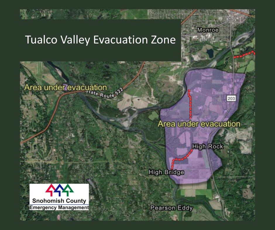
TUALCO VALLEY: This is Sno Co Sheriff. Low-lying homes in your area will see flooding overnight. Roads will be covered. Seek high ground now. Take pets and essentials with you.
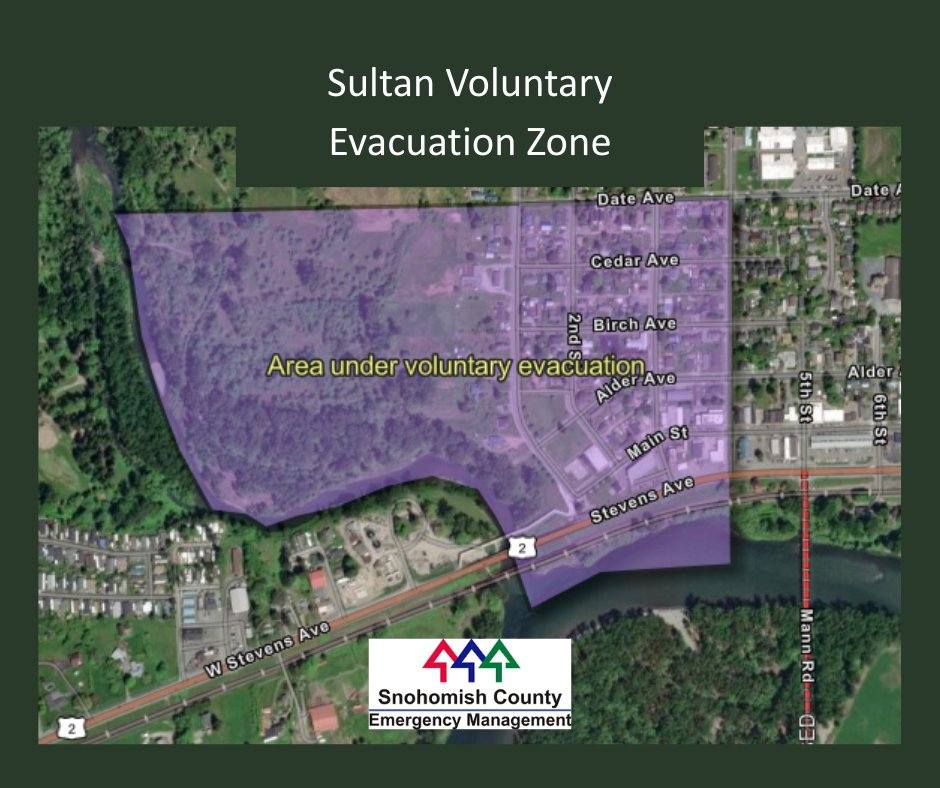
SULTAN: This is Sno Co Sheriff. Rivers rising. Sultan residents south of Date Street and west of 4th Street consider relocating now. Conditions may worsen through this evening. Emergency shelter is available at the Evergreen State Fairgrounds in Monroe. Please do not drive through standing water and follow all road closures.
![]() All Snohomish County rivers are under flood warning and expected to crest today or overnight.
All Snohomish County rivers are under flood warning and expected to crest today or overnight.
– Ebey Island and low-lying areas west of Sunnyside Blvd have been ordered to evacuate. More information below in the 7 p.m. Dec 9, 2025 update.
– Stillaguamish River at Arlington is forecast to crest at 24 feet at 10 p.m. Wednesday. Major flooding is 19 feet and the record is 21.3 feet.
– Skykomish River near Gold Bar is forecast to crest at 22.9 feet at 4 p.m. Wednesday. The river has already surpassed major flooding.
– Snohomish River at Snohomish is forecast to crest at 32 feet at 2 a.m. Thursday. Major flooding is at 29 feet and the record is 33.5 feet.
A similar emergency proclamation was signed for Snohomish County on Tuesday, with anticipated ongoing impacts to roads and transportation, emergency services, and private and public properties.
“Flooding events like this have serious impacts on our communities, particularly our rural areas, and the safety of residents is our highest priority as we proactively declare a state of emergency and put our planning and preparation to work,” said Snohomish County Executive Dave Somers. “We have a very capable emergency management team and public safety agencies, and I want to thank them for their work to protect residents and property. I urge everyone to stay informed and to stay away from floodwaters and off water-covered roadways.”
![]() DEC 9, 2025 [7 PM] SNOHOMISH COUNTY SHERIFF FLOOD AND EVACUATION ALERTS
DEC 9, 2025 [7 PM] SNOHOMISH COUNTY SHERIFF FLOOD AND EVACUATION ALERTS![]()
![]() Dikes around Ebey Island are expected to over top by major flooding by midday Wednesday 12/10/25. An evacuation order is expected 1 pm 12/10/25. When leaving, prepare to not return for several days. Take pets and essentials with you.
Dikes around Ebey Island are expected to over top by major flooding by midday Wednesday 12/10/25. An evacuation order is expected 1 pm 12/10/25. When leaving, prepare to not return for several days. Take pets and essentials with you.
![]() Evacuations: Ebey Island and Sunnyside Blvd: Dikes are expected to be over topped midday December 10, 2025, flooding Ebey Island and lowlands west of Sunnyside Blvd. An evacuation is anticipated to be issued at about 1 p.m. December 10, 2025. See the Evacuation Information map below. If you leave in the morning on Wednesday, expect not to return for several days. Bring pets and essential items with you.
Evacuations: Ebey Island and Sunnyside Blvd: Dikes are expected to be over topped midday December 10, 2025, flooding Ebey Island and lowlands west of Sunnyside Blvd. An evacuation is anticipated to be issued at about 1 p.m. December 10, 2025. See the Evacuation Information map below. If you leave in the morning on Wednesday, expect not to return for several days. Bring pets and essential items with you.
![]() Flood warnings continue for Snohomish County rivers Wednesday as another round of wet weather is forecast to bring more high water. Major flooding is expected on the Skykomish, Snohomish and mainstem Stillaguamish rivers in the hours ahead. Meanwhile, moderate flooding is forecast on both forks of the Stilly upstream of Arlington.
Flood warnings continue for Snohomish County rivers Wednesday as another round of wet weather is forecast to bring more high water. Major flooding is expected on the Skykomish, Snohomish and mainstem Stillaguamish rivers in the hours ahead. Meanwhile, moderate flooding is forecast on both forks of the Stilly upstream of Arlington.
![]() Numerous roads have been closed in Snohomish County due to flooding. Here’s a list:
Numerous roads have been closed in Snohomish County due to flooding. Here’s a list:
- Pioneer Highway (Stanwood) is closed between 212th Street NE and 236th Street NW is closed due to water over the roadway.
- Pioneer Highway (Stanwood) is closed between Marine Dr and 70th Ave NW.
- Ben Howard Road (Monroe) is closed between the 23900 block and 260th Ave SE due to water over the roadway.
- Crescent Lake Rd (Monroe) is closed from High Bridge Road to 203rd Street SE due to water over the roadway.
- 399th Ave SE (Gold Bar) is closed from the 40400 block to the end of the street due to water over the roadway.
- 311th Ave SE (Sultan) is closed from N Skyview Dr to Ben Howard Rd due to water over the roadway.
- Reiter Rd (Ave A) (Index) is closed between 109th and 125th due to trees down.
![]() Animal Stabling: Free emergency stabling for livestock is available at:
Animal Stabling: Free emergency stabling for livestock is available at:
- Evergreen Fair State Park (no dogs or swine). Contact Jeff Ritter: 425-309-2655.
- Darrington Rodeo Grounds (no swine) at 42109 SR 530 NE, Darrington, WA 9824. Contact Gabby Wesson (425) 407-2899.
Stables are uncovered. Call ahead for either location.
Moderate to major flooding has occurred or is forecast to occur in the coming days on the Snohomish, Skykomish, and Stillaguamish rivers in Snohomish County, with potential to reach or exceed historic flood levels, the county said.
Significant rainfall began Monday, driving up water levels in local rivers. Another surge of water is likely later in the week and is anticipated to raise river levels again on or around Thursday.
By Tuesday morning, water over the pavement had closed roads near Stanwood, Snohomish, Monroe, Gold Bar, Sultan, and Index. The Snohomish County Sheriff’s Office reported that several vehicles became stuck when drivers tried to navigate through water on the roadway, which is a highly dangerous thing to attempt.
Snohomish County is advising drivers to not go past “Road Closed” signs, regardless of the size of their vehicle or their familiarity with the road. As little as 6 inches of moving water is deep enough to topple an adult or to reach the bottom of most passenger cars. A foot of water will float many vehicles, and two feet of rushing water has the force to sweep away vehicles, including sport utility vehicles and pick-up trucks.
First responders also assisted individuals who were not in vehicles but had become stranded in flooded areas, and a mobile home park near Monroe was being evacuated Tuesday morning due to flood concerns.
The County plans to work alongside partners in cities, schools, and emergency services to monitor the situation and provide information and resources as the flood event continues over the next few days.
“We’ve made it through the first part of this weather challenge, but the forecasts tell us we need to prepare for another, bigger surge of rain and high water later this week,” Snohomish County Emergency Management Director Lucia Schmit said. “We need everyone to stay vigilant and informed and to look out for each other.”
Heavy rainfall has increased landslide risk on steep, soggy slopes, and the saturated soil boosts risks of falling trees and power outages, particularly if there are windy conditions in the coming days. Snohomish County officials are advising people to avoid sheltering in heavily wooded areas, especially during periods of wind and heavy rain.
Cold weather shelters have been opened to provide safe places for unsheltered people who are affected by this weather emergency. Snohomish County also opened emergency stabling at the Evergreen State Fair Park in Monroe for livestock evacuated from flood areas.
People living in flood-prone areas should remain ready to evacuate their homes and if advised to leave, do so immediately. Evacuation is simpler and safer before flood waters cover roads and limit travel options.
The widespread flooding has caused dangerous road conditions which impact emergency response, including potential delayed response due to impassable roads and additional resource needs for water rescue.
Snohomish County’s proclamation allows the County to spend public funds to take reasonable and prudent measures ensuring the safety of residents and waives some administrative requirements in order to expedite response efforts, the county said. It directs county departments to take actions to mitigate and prevent impacts upon private property and publicly owned infrastructure.
Elsewhere in the state (those living in Orting, near the Puyallup River, for example) have even been called to evacuate, with a Level 3 “GO NOW” evacuation order.
The NWS also warned communities along the Lower Yakima River and the Columbia River to brace for flooding, which could pose serious threat to life and property.
“We are working to get federal assistance immediately available to respond to the potential once-in-a-lifetime flooding in the State of Washington, especially around the Puget Sound, north Cascades, and low-lying areas east of the mountains. NOAA forecasters are anticipating potentially record-breaking flooding along the Skagit, Snohomish, and Columbia rivers tonight and tomorrow,” said Senator Maria Cantwell Wednesday. “To folks in those areas, please pay attention to emergency alerts, follow instructions from the local authorities, and be prepared to move to protect yourself and your loved ones.”
According to the National Oceanic and Atmospheric Administration (NOAA): “Ongoing major flooding across the Northern Cascades and Puget Sound regions of the Pacific Northwest is expected to worsen and likely reach record levels later this week.”
Locally catastrophic river flooding is likely, especially along the Skagit and Snohomish Rivers, the NOAA continued.
Cantwell’s office said as many as 34 gaged locations along major streams and rivers in the region have reached, or are forecast to reach, moderate-to-major flood stage this week, among these the Snohomish River near Monroe.
With rivers already at moderate-to-major flood stage across the region, another surge of heavy rainfall is likely today and into tomorrow bringing an additional 4-6 inches of rain to the Olympics and Cascades, with localized amounts of up to 10 inches possible.
This comes after more than two days of heavy rainfall that has already produced 8-10 inches of rainfall across the Cascades, which could potentially also lead to landslides and debris flow, especially in recently burned areas.
Numerous landslides have already been reported across the region, including one that closed eastbound lanes of Interstate 90 near North Bend, WA, for six hours Monday night and another on Tuesday between SR-18 and North Bend
Several dams and levees in the region are being monitored for overtopping and/or failure, including the Lake Sylvia Dam, Howard Hanson Dam, and Mud Mountain Dam.
For updates on flooding in Snohomish County, including evacuation notices and road closures, click here.

Author: Kienan Briscoe