EVERETT—Snow is accumulating in Washington’s Cascade Mountains as a series of weather systems deliver much-needed precipitation this week, but experts warn the gains are insufficient to overcome a severe snow drought that has plagued the state throughout the winter.
The National Weather Service has issued a winter weather advisory for the South Washington Cascades on Monday, Feb. 16, forecasting 4 to 9 inches of new snow through Monday night, followed by additional rounds of 2 to 5 inches Tuesday, 5 to 10 inches Wednesday and another 5 to 10 inches Thursday. The advisory remains in effect until early Friday morning, with snow levels dropping to around 1,000 to 1,500 feet by Tuesday, potentially affecting travel over mountain passes.


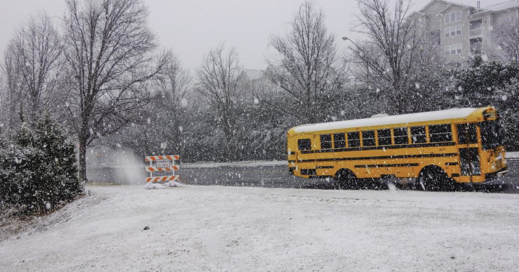
In Snohomish County, which encompasses coastal lowlands around Everett and higher elevations in the North Cascades, forecasts call for mixed rain and snow at lower altitudes, with highs in the mid-40s and lows dipping to the upper 20s to low 30s through midweek. Accumulating snow is more likely in Snohomish County’s mountainous areas, where 5 to 10 inches could fall by Wednesday morning.
Statewide, the snowpack stands at less than 50% of normal levels as of early February, with 82% of monitoring stations in Washington reporting snow drought conditions. The North Cascades fare slightly better at around 54% of average, but southern and central regions lag below 40%. Warmer-than-average temperatures and below-normal precipitation earlier in the season have contributed to the deficits, raising concerns for water supply, agriculture and recreation come spring.


A second frontal system is expected to move onshore over the West Coast Tuesday evening, advancing eastward to the Rockies by Wednesday, the NWS Weather Prediction Center announced. This will produce lower-elevation rain and higher-elevation snow across Washington, with continued snowfall in the Northern Intermountain Region and Great Basin.
Travelers are advised to check road conditions, as mountain passes like Stevens Pass in the North Cascades may see impacts from fresh snow and reduced visibility. No widespread lowland snow is expected in Snohomish County’s urban areas, but isolated flurries could occur overnight as temperatures drop.
Detailed Forecast for Everett Area
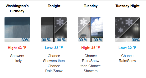
Monday morning, February 16
- High: 43 °F
- Conditions: Showers Likely
- Details: Showers likely, mainly before 5pm. Mostly cloudy, with a high near 43. South southeast wind around 9 mph. Chance of precipitation is 60%. New precipitation amounts of less than a tenth of an inch possible.
Monday Night
- Low: 33 °F
- Conditions: Chance Showers then Chance Rain/Snow
- Details: A chance of rain showers before 2am, then a chance of rain and snow showers. Mostly cloudy, with a low around 33. South southeast wind 6 to 8 mph. Chance of precipitation is 30%. Little or no snow accumulation expected.
Tuesday morning, February 17
- High: 45 °F
- Conditions: Chance Rain/Snow then Chance Showers
- Details: A chance of rain and snow showers before 10am, then a chance of rain showers. Partly sunny, with a high near 45. Southeast wind 3 to 5 mph. Chance of precipitation is 30%. Little or no snow accumulation expected.
Tuesday Night
- Low: 32 °F
- Conditions: Chance Rain/Snow
- Details: A chance of rain and snow showers. Mostly cloudy, with a low around 32. Light east southeast wind. Chance of precipitation is 30%. Little or no snow accumulation expected.
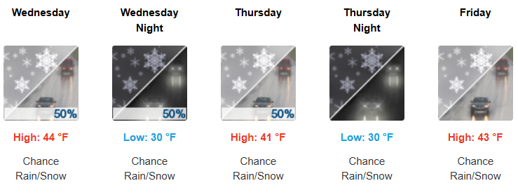
Wednesday morning, February 18
- High: 44 °F
- Conditions: Chance Rain/Snow
- Details: A chance of rain and snow showers before 1pm, then a chance of rain showers. Mostly cloudy, with a high near 44. South wind 3 to 5 mph. Chance of precipitation is 50%. Little or no snow accumulation expected.
Wednesday Night
- Low: 30 °F
- Conditions: Chance Rain/Snow
- Details: A chance of rain and snow showers. Mostly cloudy, with a low around 30. Chance of precipitation is 50%. New snow accumulation of less than a half inch possible.
Thursday morning, February 19
- High: 41 °F
- Conditions: Chance Rain/Snow
- Details: A chance of rain and snow showers. Partly sunny, with a high near 41. Chance of precipitation is 50%. New snow accumulation of less than a half inch possible.
Thursday Night
- Low: 30 °F
- Conditions: Chance Rain/Snow
- Details: A chance of rain and snow showers before 1am, then a chance of snow showers. Mostly cloudy, with a low around 30.
Friday morning, February 20
- High: 43 °F
- Conditions: Chance Rain/Snow
- Details: A chance of snow showers before 10am, then a chance of rain and snow showers. Mostly cloudy, with a high near 43.
Friday Night
- Low: 33 °F
- Conditions: Chance Rain/Snow
- Details: A chance of rain and snow showers. Mostly cloudy, with a low around 33.
Saturday morning, February 21
- High: 49 °F
- Conditions: Chance Rain/Snow
- Details: A chance of rain and snow showers. Mostly cloudy, with a high near 49.
Saturday Night
- Low: 38 °F
- Conditions: Chance Showers
- Details: A chance of showers. Mostly cloudy, with a low around 38.
Sunday morning, February 22
- High: 52 °F
- Conditions: Showers Likely
- Details: Showers likely. Mostly cloudy, with a high near 52.
Sunday Night
- Low: 39 °F
- Conditions: Showers Likely
- Details: Showers likely. Mostly cloudy, with a low around 39.
Monday morning, February 23
- High: 51 °F
- Conditions: Showers Likely
- Details: Showers likely. Mostly cloudy, with a high near 51.

Author: Mario Lotmore