

MIAMI — A strengthening El Niño has produced one of the starkest contrasts in modern tropical cyclone records, leaving the Atlantic hurricane basin nearly silent through its statistical peak while turning the Pacific into a prolific storm factory.
As of Saturday, September 12, the Atlantic had generated only five named tropical storms and zero hurricanes, marking a new satellite-era record for the latest first hurricane of a season, surpassing the previous September 11 dates set by Hurricane Gustav in 2002 and Hurricane Humberto in 2013, according to CNN. Accumulated cyclone energy, a measure combining storm intensity and duration, stood at roughly 4.4 units — less than 10 percent of the typical mid-September total and the lowest through this date since at least 1950, Colorado State University researcher Philip Klotzbach said.


“It’s just hammering the Atlantic,” Klotzbach said. “We haven’t even had anything really even close to a hurricane.”
The same can’t be said the across the Pacific. The eastern Pacific had already produced 14 named storms, several of which became hurricanes, including major hurricanes and Category 5 Hurricane Lowell, per National Hurricane Center seasonal summaries. The combined northeastern Pacific, has accumulated cyclone energy of about 177 units, already exceeding a typical full-season’s average.



In the central Pacific, Hurricane Lala became the first hurricane to make a direct hit on Hawaii’s Big Island since 1871. The western Pacific typhoon basin had generated 23 named storms by early September, with 14 forming in July and August alone — a mid-season burst matching some of the busiest stretches on record.
Matthew Rosencrans, NOAA’s lead seasonal hurricane forecaster, explained the contrast.
“El Niño increases vertical wind shear over the tropical Atlantic, with the strongest signal over the Caribbean,” he told ABC News. “This year, vertical wind shear has been very high over the Caribbean, much of the Gulf, and the deep tropical Atlantic.”
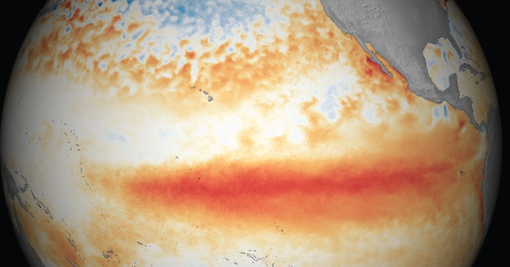
El Niño occurs when trade winds weaken and unusually warm water spreads eastward along the equatorial Pacific, rearranging atmospheric circulation. The resulting upper-level westerlies over the Atlantic tilt and tear apart developing storms. In the eastern and central Pacific, the same pattern reduces shear, warms sea-surface temperatures, and supports persistent thunderstorms that seed tropical cyclones.
NOAA’s Climate Prediction Center first flagged a high probability of a strong El Niño, predicting an 82% chance of development between May and July and a 96% chance it would persist through the Northern Hemisphere winter, the Lynnwood Times reported in May. By September the event had intensified further, with sea-surface temperature anomalies exceeding 3 degrees Celsius in parts of the eastern equatorial Pacific. Forecasters placed a greater than 90% chance on a very strong event lasting through fall and winter 2026-27, and a 75% chance that the October-December period would produce a historic event exceeding any El Niño since 1950, according to NOAA CPC diagnostics.
The pattern now appears to match previous strong El Niño years such as 1982, 1997 and 2015, when the Atlantic was similarly suppressed and the Pacific unusually active, University of Miami scientist Andy Hazelton said. Recurring outbreaks of dry Saharan dust that sinks to the ground have further intensified the unfavorable conditions in the Atlantic.
The National Hurricane Center reported no tropical cyclone development expected in the Atlantic for at least the next seven days. In the eastern Pacific, Tropical Storm Norbert was tracking west-northwest well offshore of Mexico, with additional areas under watch for possible formation.
Historically, more than half of a season’s hurricane activity can still occur after September 10 in the Atlantic, so forecasters caution that a quiet first half of the Atlantic season does not eliminate late-season risk in the Western Caribbean and Gulf of Mexico. However, as long as El Niño remains strong, the fundamental contrast of a suppressed Atlantic and an energized Pacific is expected to persist through the remainder of the official hurricane and typhoon seasons that end November 30, 2026.
As residents in the Pacific Northwest gear up for winter, keep in mind that this same El Niño, according to NOAA, is also projected to shift the Pacific jet stream southward producing warmer and drier conditions and reduced mountain snowpacks.
Currently, a marine heatwave that began in May 2025 has kept waters off Southern and Central California well above average through summer 2026. Buoy records in late August 2026 showed Santa Monica Bay and Torrey Pines running about 6°F above their long-term averages (roughly 74°F and 77°F). NOAA has classified the Southern California region as being in a marine heatwave, with temperatures generally 3–4°F above normal. Daily records were repeatedly broken at some sites.
This warmth is not solely from the current El Niño as the warming predated the strong equatorial warming. However, El Niño’s influence is expected to add more heat to waters off the West Coast this fall and winter in Oregon and Washington, and continue to persist off California through the end of 2026 as El Niño strengthens.

Author: Mario Lotmore