SNOHOMISH COUNTY, December 23, 2022—The National Weather Service (NWS) has issued a Flood Watch from Friday night until Sunday night due to forecasted excessive rainfall. A much warmer and wetter weather system will begin to move into the area early Saturday morning bringing moderate to heavy precipitation and elevated snow levels – above 7000 feet – through the weekend.
The Flood Watch is in effect for portions of northwest and west central Washington, including the following counties: Mason, Skagit, Snohomish and Whatcom.


Excessive runoff may result in flooding of rivers, creeks, streams, and other low-lying and flood-prone locations. Additional contributing factors include the potential for rain falling on existing snow and snow melt which could lead to additional or enhanced runoff. Flooding may occur in poor drainage and urban areas.
While some rivers are forecast to exceed flood stage, and all area rivers will see rises – widespread river flooding is not expected at this time through Sunday night.


NWS advises residents to monitor later forecasts and be alert for possible Flood Warnings. Those living in areas prone to flooding should be prepared to take action should flooding develop.
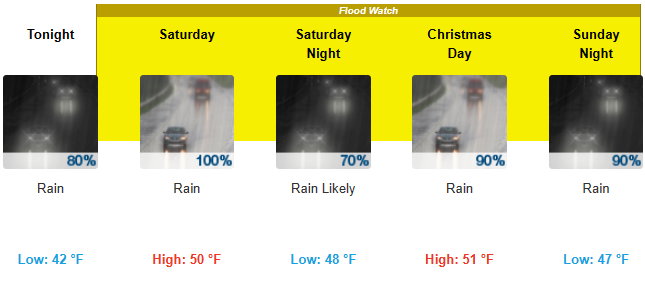
- Friday Night: Rain. Steady temperature around 42. Southeast wind 11 to 13 mph. Chance of precipitation is 80%. New precipitation amounts between a tenth and quarter of an inch possible.
- Saturday (Dec 24): Rain. High near 50. South southeast wind 10 to 15 mph, with gusts as high as 23 mph. Chance of precipitation is 100%. New precipitation amounts between a quarter and half of an inch possible.
- Saturday Night: Rain likely, mainly before 10pm. Cloudy, with a steady temperature around 48. Southeast wind around 7 mph. Chance of precipitation is 70%. New precipitation amounts of less than a tenth of an inch possible.
- Sunday (Dec 25): Rain, mainly after 10am. High near 51. Southeast wind 7 to 9 mph. Chance of precipitation is 90%. New precipitation amounts of less than a tenth of an inch possible.
- Sunday Night: Rain. Low around 47. Southeast wind 10 to 14 mph. Chance of precipitation is 90%. New precipitation amounts between a quarter and half of an inch possible.
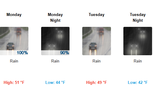
- Monday (Dec 26): Rain. High near 51. Chance of precipitation is 100%. New precipitation amounts between a quarter and half of an inch possible.
- Monday Night: Rain. Low around 44. Chance of precipitation is 90%.
- Tuesday (Dec 27): Rain. Cloudy, with a high near 49.
- Tuesday Night: Rain. Cloudy, with a low around 42.
- Wednesday (Dec 28): Rain. Cloudy, with a high near 45.
- Wednesday Night: Rain likely. Cloudy, with a low around 38.
- Thursday (Dec 29): Rain likely. Cloudy, with a high near 45.
- Thursday Night: Rain. Cloudy, with a low around 39.
- Friday (Dec 30): Rain likely. Cloudy, with a high near 46.
To learn what types of flooding are typical in Washington and how do you protect yourself, your family and your home, click HERE.

Author: Lynnwood Times Staff


One Response