EVERETT– The Snohomish County Department of Emergency Management is now seeking public comment on a draft plan to help people and businesses better adapt to wildfire risks. The first-ever Snohomish County Community Wildfire Protection Plan contains dozens of recommended strategies for improving forest health and enhancing wildfire preparedness. It represents nearly two years’ work by a team that included area firefighters, state and federal agencies, local tribes, nonprofits, residents, landowners and Emergency Management staff.
“This draft document is the result of a tremendous collaborative effort over the last 20 months that included 50 planning partners, over 1,000 public comments, and feedback at two open houses,” said Lucia Schmit, the County’s director of Emergency Management. “The last step in this process before we send it to the state for review is for the residents to take a look and let us know if they have any concerns. We hope they will take the time.”


The plan is available for review at www.bit.ly/SnoCo_CWPP. Public comment is being accepted through July 30 using this survey form www.bit.ly/Comment_SnoCo_CWPP and at DEMPlanning@snoco.org.
“I want to thank all the partners who have been involved in this important planning effort to help us better understand and prepare for the increasing risk of wildfire in our county,” County Executive Dave Somers said. “I encourage people who live in Snohomish County to take some time and look over the plan and provide feedback. More importantly, I urge them to learn more about potential wildfire risk where they live and about the actions we all can take to keep ourselves, our families and our community safe.”


The wildland fire season in Snohomish County historically has stretched from early July through the rains of fall. Warmer, drier weather in recent years has heightened concern about fire frequency and intensity. The 2022 Bolt Creek Fire, for example, scorched nearly 15,000 acres across east King and Snohomish counties. It forced multiple safety closures that blocked U.S. 2 and unleashed smoke that repeatedly degraded air quality to dangerous levels across much of the community.
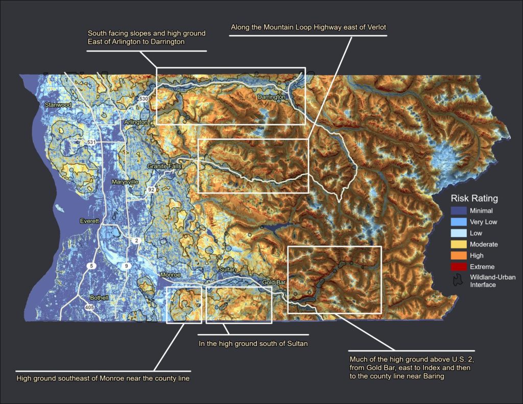
The community wildfire planning effort used geospatial analysis to identify places in the county where topography and ground cover contribute to elevated fire risk. Related data work identified areas where houses, farms and businesses mix in with forestlands. Roughly 130,000 people in the county now call these spaces home – more than 15% of the county’s population.

The plan provides a framework for ensuring coordinated wildfire mitigation, preparedness, evacuation, post-fire recovery, and outreach efforts. It identifies 33 objectives and 70 strategies. Among the recommendations are guidelines for projects to reduce the brush and other woody fuels that can prime forestlands for destructive fires and improved access to information about making homes and property more fire-resistant.
Source: Snohomish County Department of Emergency Management

Author: Lynnwood Times Staff