

MUKILTEO — The City of Mukilteo has taken its first formal step toward revitalizing a long-underutilized stretch of city-owned shoreline, releasing a Request for Qualifications (RFQ) on July 29, 2026, that invites experienced development teams to compete for the chance to lease and develop a 1.19-acre waterfront site on Puget Sound as part of the Mukilteo Waterfront Redevelopment Project.
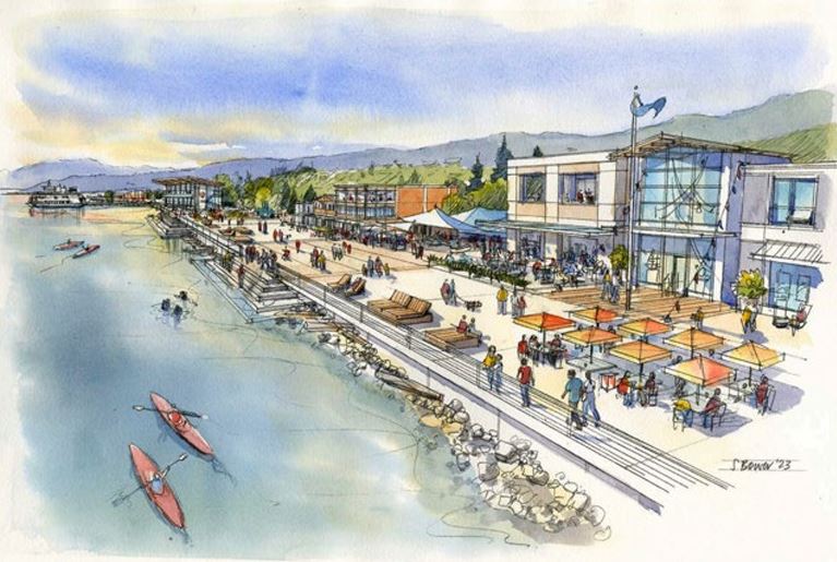
The primary site, known as Lot 5, sits at the heart of Mukilteo’s emerging waterfront district, just steps from the Washington State Ferry Terminal—one of the system’s three busiest routes, carrying approximately 3.7 million riders annually to Whidbey Island—and within walking distance of the historic 1906 Mukilteo Lighthouse, Lighthouse Park, and the Sound Transit Sounder commuter rail station linking Mukilteo to Seattle and Everett.
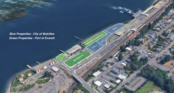
of Everett’s properties (green). Source: City of Mukilteo GIS
Statements of Qualifications are due September 9, 2026. Selected teams will advance to a Request for Proposals (RFP) phase before the city chooses a preferred long-term development partner. A structured site tour is scheduled for August 19 at 11 a.m., with interested teams strongly encouraged to attend.
“Mukilteo’s waterfront is one of our community’s greatest gifts. Our vision is a place that feels genuinely like Mukilteo: walkable, welcoming, alive with activity, and deeply rooted in the maritime heritage and indigenous history of this place. We want people to come here and never want to leave,” said Mayor Joe Marine.




RFQ Requirements and Process
This is a two-step competitive process emphasizing long-term partnership capacity given the regulatory, environmental, and infrastructure complexities. Statements of Qualifications must include:


- A letter of interest and executive summary with team overview and organizational chart.
- A detailed development approach covering site feasibility and pro forma methods, conceptual-plan methods aligned with the Vision and Guiding Principles (use types, square footages, access, parking, utilities—methods only at this stage), overall timeline, promenade coordination and funding, optional approach to Lots 2 and 3, and residential contingency planning if applicable.
- Evidence of comparable experience (scale, complexity, mixed-use, public-private partnerships; brownfield or waterfront experience preferred), identification of key personnel, and subconsultant qualifications.
- Three client references (at least two from the past three years).
- Demonstration of financial capacity, including past funding approaches, proposed financing strategy, lender relationships, and equity partners.
- Optional additional information.
Evaluation criteria weight financial resources and comparable experience at 30 points each, project approach and vision at 25 points, and team qualifications and communication at 15 points. A shortlist of two to three teams will be invited to the RFP stage, where full conceptual designs, pro formas, timelines, and proposed lease terms will be required.

Key remaining dates include evaluation completion around September 16, selection of RFP invitees by September 23, RFP proposals due October 28, interviews November 11, final selection around November 13, a presentation to the City Council and community in mid-to-late November, and the start of lease and development-agreement negotiations in December 2026. All dates are subject to change with updates will be posted on the City’s website.
The full RFQ, environmental reports, zoning documents, parking study, and other supporting materials are available at https://mukilteowa.gov/bids.aspx?bidID=20. Questions must be submitted in writing to the City Clerk by August 24.
Deal Structure
The selected partner by the City of Mukilteo will enter a long-term ground lease on Lot 5 with an initial 50-year term plus three 10-year extension options, for a total of up to 80 years. The City retains land ownership while the private partner constructs, develops, finances, and operates the project. A concurrent development agreement will set milestones, design standards, public amenity commitments, and mutual obligations. The City is prepared to structure the lease to support leasehold financing and future recapitalization or resale of the leasehold interest.
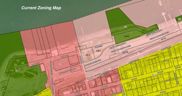
Source: City of Mukilteo Community Development
Adjacent City-owned Lots 2 and 3 (approximately 1.79 acres combined) may be incorporated, leased separately (for example for parking or complementary uses), or declared surplus for sale, subject to later City Council determination in coordination with the selected team and the Port’s program. Teams are encouraged to address these parcels in their submissions.
The City is positioning itself as a collaborative partner rather than a passive landlord. Potential incentives and support include contributions toward the waterfront promenade (a continuous pedestrian amenity for which land has already been set aside along Lot 5), long-term parking solutions, and other public infrastructure; active pursuit of grant funding; streamlined priority permitting with a dedicated ombudsman; possible reduced parking standards and shared-parking strategies; discounted building-permit fees; and the absence of a local business-and-occupation tax. Utility extensions (water, sewer, stormwater, and modern electrical service) will be required and represent a material project cost to the selected team.
Lot 5 is currently zoned Open Space and is undergoing a comprehensive-plan amendment and rezone to Waterfront Mixed Use (expected by November 2026) to align with Lots 2 and 3. All three lots fall within the Urban Waterfront shoreline environment. Residual subsurface contamination from the former tank farm is present but manageable; the surface is clean. Residential use is currently prohibited by a 2013 environmental covenant; any modification would require additional investigation and approvals that could take up to three years with no guarantee of success. Teams interested in residential components must treat these as contingent and demonstrate commercial-only viability as a fallback.
Background: A Decades-Long Path to Redevelopment
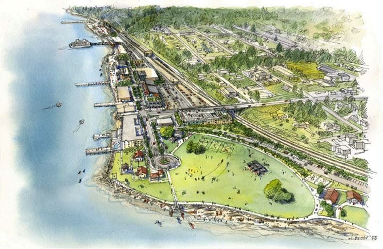
The broader Mukilteo waterfront corridor spans roughly 26 acres from Lighthouse Park toward Edgewater Beach and involves multiple ownerships—currently around 10 to 11 entities including the City of Mukilteo, the Port of Everett, private owners, tribal interests, and the State of Washington. Approximately 70 percent of the corridor remains undeveloped.
“We are looking forward to working with the City of Mukilteo on the redevelopment of the waterfront. It is our shared goal to create a destination that honors the rich history and small beach town vibe that is Mukilteo,” Lisa Lefeber, CEO Port of Everett.
Development has been delayed for nearly two decades by a complex history of governmental uses and ownership transfers. The area includes former tidelands settled in the 1850s, a lumber mill that employed Japanese immigrant workers in what became known as Japanese Gulch, a World War II ammunition shipping point, and the U.S. Air Force Mukilteo Tank Farm (1951–1989). Significant remediation followed tank farm closure; the Washington State Department of Ecology issued a No Further Action determination in 2006.
The Port of Everett acquired the former tank farm site and later conveyed portions to stakeholders. In 2013 the National Oceanic and Atmospheric Administration canceled plans for a major research facility, returning key land to the Port. On January 4, 2016, the Mukilteo City Council adopted the Downtown Waterfront Master Plan, which envisioned local businesses, a looped pedestrian promenade, bike lanes, and playful waterfront uses while celebrating the shoreline’s past, present, and future and adapting to the relocated ferry terminal.
In 2022 the Port partnered with the City and hired Seattle firm NBBJ to lead community engagement, stakeholder workgroups, and visioning. That process produced the adopted vision and guiding principles now governing both agencies’ efforts. The Port has since secured the former NOAA site and additional parcels (including property housing Ivar’s Mukilteo Landing) and is preparing its own parallel developer solicitation. Together the City and Port control strategically positioned acreage at the corridor’s core.
The City’s Vision
The formally adopted Vision Statement for the Mukilteo Waterfront Redevelopment Project was developed with extensive public input and approved by both the City Council and Port Commission, reads: “Mukilteo’s waterfront is a welcoming and convenient gathering place. It provides a year-round mix of uses that promotes culture, recreation and entertainment. It offers easy access to the beach, businesses and wonders of the Salish Sea.”
Guiding principles state that the development is to be authentically Mukilteo, pedestrian-friendly, a year-round destination, environmentally responsible and sustainably minded, culture-celebrating honoring the Snohomish Peoples and the significance of the 1855 Point Elliott Treaty site, education-focused, a transportation and maritime hub, supportive of boating and shoreline access, and equipped with thoughtful parking.
The City is not seeking a generic mixed-use project. Desired elements include restaurants and cafés with waterfront views, boutique retail, a hotel or inn at the edge of Puget Sound, public plazas and gathering spaces, and a continuous promenade connecting the ferry terminal to Lighthouse Park. Architecture and public spaces should feel rooted in Pacific Northwest character, respect Indigenous heritage through interpretive elements and public art, and remain open and welcoming to everyone.
Opportunity for the Region
The ferry terminal delivers roughly 10,000 people to the waterfront daily. Snohomish County has grown rapidly—nearly 16 percent between 2010 and 2020—driven by Boeing, Paine Field, and the tech corridor. The County’s population is projected to reach 1.1 million by 2044. Mukilteo itself boasts high purchasing power, with a median household income of approximately $132,861—well above national and Seattle-metro averages—and a homeownership rate exceeding 70 percent.
Redevelopment is expected to catalyze complementary activity across the larger corridor, enhance public access and the shoreline experience, support multi-modal transportation, and create a defining destination for residents, ferry passengers, and regional visitors.

Author: Mario Lotmore