
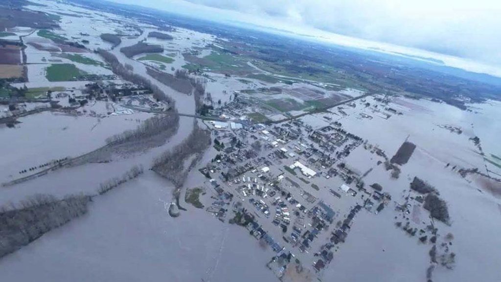
SNOHOMISH COUNTY—To assist residents before, during and after a flood event, Snohomish County wants them to start planning for inclement winter weather. The National Weather Service has announced the Winter Outlook for December 2026 through February 2027. Predictions indicate that this winter likely will favor warmer temperatures and rain – also known as El Niño. Resources and services are provided by several departments including Department of Emergency Management (DEM), Department of Conservation and Natural Resources (DCNR), Health Department, Planning and Development Services (PDS), and Public Works (PW).
As residents prepare for the coming winter months, below are key actions to take:


- KNOW YOUR AREA – Determine if you are located in a river floodplain or travel through one to get to work, school or reach other family. Learn which hazards are near you with Snohomish County Hazard Viewer. You can search by address and risks.
- HAVE A PLAN – Use this checklist to plan alternate routes or make plans if you can’t get in or out of your neighborhood. Build a kit and become more prepared.
- STAY INFORMED –Sign up for:
- SnoCoAlerts
- Real-Time Flood Information Center river gauge alerts
- Bookmark Snohomish County Public Safety Hub: https://snoco.org/safety During a disaster, first responders and emergency managers will rely on these tools to share critical information.
Resources Provided by the Department of Conservation and Natural Resources (DCNR):
- Annual Flood Safety Guide – This guide provides information on a wide range of flood-related topics, such as researching your property’s flood risk, protecting your home from flooding, preparing for a flood, what to do in the event of a flood, and steps to recover from a flood.
- Drainage Investigation Request – Use this form to report a drainage problem.
- Flood Information Center Webpage – Visit this one-stop flood information resource.
- Flood Recovery Guide – Review this guide to learn practical steps to help recover after a flood.
- Real-Time Flood Information System – Residents can view real-time river depths and flows as well as rain gauges throughout the county. This online tool offers notifications, graphs, historical data and an interactive map. Users can subscribe to receive email and text notifications when river levels at individual gauge stations enter and exit flood phases. The notifications are based on real-time conditions and do not include forecasting future flood scenarios. Click on the down arrow next to “Subscribe to Flood Notifications” below the map to select which basin you want to subscribe to.
- Flood Insurance Rate Maps (FIRMs) – FIRMs (often called flood hazard maps) are FEMA maps showing special flood hazard areas and risk zones. They show the location of a property relative to special flood hazard areas, which is one of the factors used to determine flood insurance rates. Most home and renters’ insurance plans do not cover flooding. Public post-disaster assistance – whether from the government or nonprofit organizations – may be limited and often does not cover all losses. The National Flood Insurance Program offers coverage reflecting your home’s flood risk. Learn more at: www.floodsmart.gov.
- Emergency Stabling – In the event of a flood or other emergency that warrants this service, emergency stabling for livestock is provided at the Evergreen State Fair Park at no charge.
Resources Provided by the Department of Emergency Management (DEM):



- SnoCoAlerts – Register to receive emergency alerts delivered right to your smart phone during disasters.
- Snohomish County Public Safety Hub – DEM uses this one-stop resource to share emergency information, including real-time guidance, maps and flood forecasts.
- Snohomish County Hazard Viewer — Explore interactive maps showing known natural hazard areas, including flood zones, earthquake faults, landslide history and the potential for wildfire.
- Social Media Notices: Disaster/Flood News – Be sure to follow DEM’s Facebook and X accounts to receive updates during severe weather events.
Resources Provided by the Health Department:


- Cleaning Up After a Flood – This Emergency Flood Sanitation guide includes health and safety precautions when preparing for or returning home after a flood.
Resources Provided by Planning and Development Services (PDS):


- Development Requirements – Before building, repairing, or retrofitting a home in the flood hazard area, contact PDS to learn about applicable development requirements and permits. PDS staff can help property owners understand how to construct or retrofit their new or existing homes to be safer from flooding. Visit the PDS website or call the department for more information at 425-388-3311.
- Flood Hazard Information Service – Residents can find more information on a specific property, including location relative to the floodplain, flood zone, predicted flood depths, and natural floodplain features by contacting our office or using the PDS Map Portal.
Resources Provided by Public Works (PW):
- Clogged Drains or Culverts – Call road maintenance at 425-388-7500 Monday through Friday between the hours of 8:30 a.m. to 5 p.m. To report emergencies or flooding issues outside of these hours, call 911.
- Road Closure Map – Active County road closures are highlighted in red on the map. Click on the highlighted section to see why a road is closed. The closure map is updated Monday through Friday from 7:00 a.m. to 4:30 p.m. but may be updated after hours during flood events at stage 3 or higher.
- Social Media Notices: Road Reports – Follow Public Works Facebook and X accounts to learn about work being done by Public Works crews during inclement weather events.

Author: Lynnwood Times Staff