SNOHOMISH COUNTY, December 16, 2022—Much cooler weather expected in Snohomish County this weekend through Thursday with temperatures fluctuating between a low of 25°F to a high of 40°F (three degree drop in both low and high temperatures) according to the National Weather Service. Rain/Snow expected late Saturday morning that will transition to a light accumulation of snow by that evening and will last until Sunday.
For a list of cold weather and daytime warming shelters, click here.


Snohomish County Prepared for Upcoming Snow Event
Before heading out, it is highly recommended that commuters check their travel routes and options. For those venturing through unincorporated Snohomish County, visit the Public Works Snow and Ice webpage to view the priority routes for snowplowing, sanding and road closure information. The prioritization of snow and ice routes are based on traffic volume, transit and school bus routes, hospitals and clinics, terrain, and knowledge of problem areas. The prioritization does not change based on public calls – even multiple calls – requesting service.
“Despite the snow event earlier this season, we have enough salt, sand, and mixed products available for at least seven continuous (24/7) days of snow and ice fighting,” Public Works Director Kelly Snyder said. “Steps have been taken to ensure we are able to secure additional abrasives should the need arise. The county’s fleet division is ready to repair our vehicles and replace our plow blades. Public safety is our number one priority.”


Monday commuters should expect hazardous road conditions. With the upcoming snow event forecasted, Snohomish County crews and plows are scheduled to work on clearing designated priority snow and ice removal routes. Road Maintenance teams are equipped and stocked with sand, salt and other supplies.
The Road Maintenance Division is prepared with resources including:

- 38 plow/sander trucks
- Three anti-icer trucks
- 5,800 tons of sand/salt mix
- 10,000 tons of sand
- 944 tons of salt
- 22,500 gallons of anti-icing liquid (Calcium Chloride)
- 730 tons of ice kicker (blue salt)
During snow/ice weather events, it’s also important to:
- Know who to call and when:
- Life-threatening emergencies, call 911.
- Non-life threatening emergencies: 425-407-3999
- Give snowplows and deicers plenty of room to work. Allow for a minimum following distance of 200 feet from the plows and deicers while they are working.
- If you must pass, take extreme caution and beware of the displaced snow and ice, or sand spray.
- Vehicles parked along all major arterials and emergency routes must be moved off the street. It is recommended for them to be moved when snow is in the forecast.
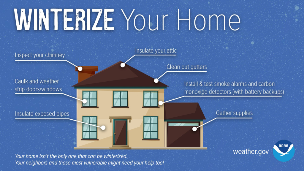
- Keep drainage inlets near your home clear of leaves and debris during the winter months to help reduce the chance of flooding.
- Try to keep garbage bins and other obstacles out of the street when the roads are icy or covered with snow.
- Obey road closed signs.
Upcoming Weather Forecast for Snohomish County – Dec 17 to Dec 23
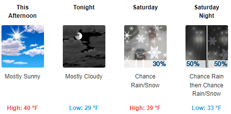
- Friday (Dec 16): Mostly sunny, with a high near 40. Calm wind.
- Friday Night: Mostly cloudy, with a low around 29. Light east-southeast wind.
- Saturday (Dec 17): A chance of rain and snow, mainly after 11am. Mostly cloudy, with a high near 39. Wind chill values between 24 and 34. Southeast wind around 6 mph. Chance of precipitation is 30%. Little or no snow accumulation expected.
- Saturday Night (Dec 18): A chance of rain before 2am, then a chance of rain and snow. Mostly cloudy, with a low around 33. Southeast wind around 5 mph. Chance of precipitation is 50%. New snow accumulation of less than a half inch possible.
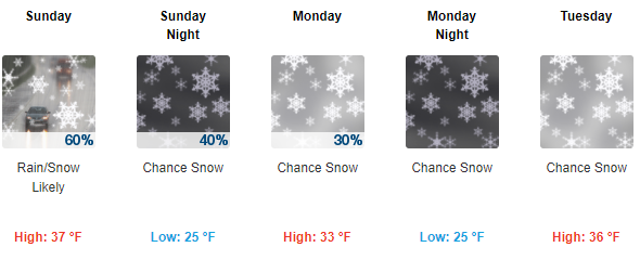
- Sunday (Dec 19): Rain and snow likely, becoming all snow after 2pm. Mostly cloudy, with a high near 37. West wind 6 to 8 mph. Chance of precipitation is 60%. New snow accumulation of less than one inch possible.
- Sunday Night: A 40 percent chance of snow. Mostly cloudy, with a low around 25. New snow accumulation of less than a half inch possible.
- Monday (Dec 20): A 30 percent chance of snow. Mostly cloudy, with a high near 33. Little or no snow accumulation expected.
- Monday Night: A chance of snow. Mostly cloudy, with a low around 25.
- Tuesday (Dec 21): A chance of snow. Mostly cloudy, with a high near 36.
- Tuesday Night: A chance of rain before 11pm, then a chance of rain and snow. Mostly cloudy, with a low around 28.
- Wednesday (Dec 22): A chance of rain and snow. Mostly cloudy, with a high near 38.
- Wednesday Night: Rain likely. Cloudy, with a low around 32.
- Thursday (Dec 23): Rain. Cloudy, with a high near 44.
Follow Snohomish County departments on social media for the most up-to-date information during an emergency event:
- Public Works on Twitter and Facebook
- Department of Emergency Management on Twitter
- Snohomish County on Twitter and Facebook
We’ll be posting an update on the forecast for this upcoming week regarding colder temperatures and potential snowfall this afternoon! In the meantime, enjoy the sunshine. #WAwx [Webcam: Rainier National Park] pic.twitter.com/yQkUEcLxsq
— NWS Seattle (@NWSSeattle) December 16, 2022
Content Source: Lynnwood Times with additions from Snohomish County Winter Storm press release

Author: Lynnwood Times Staff