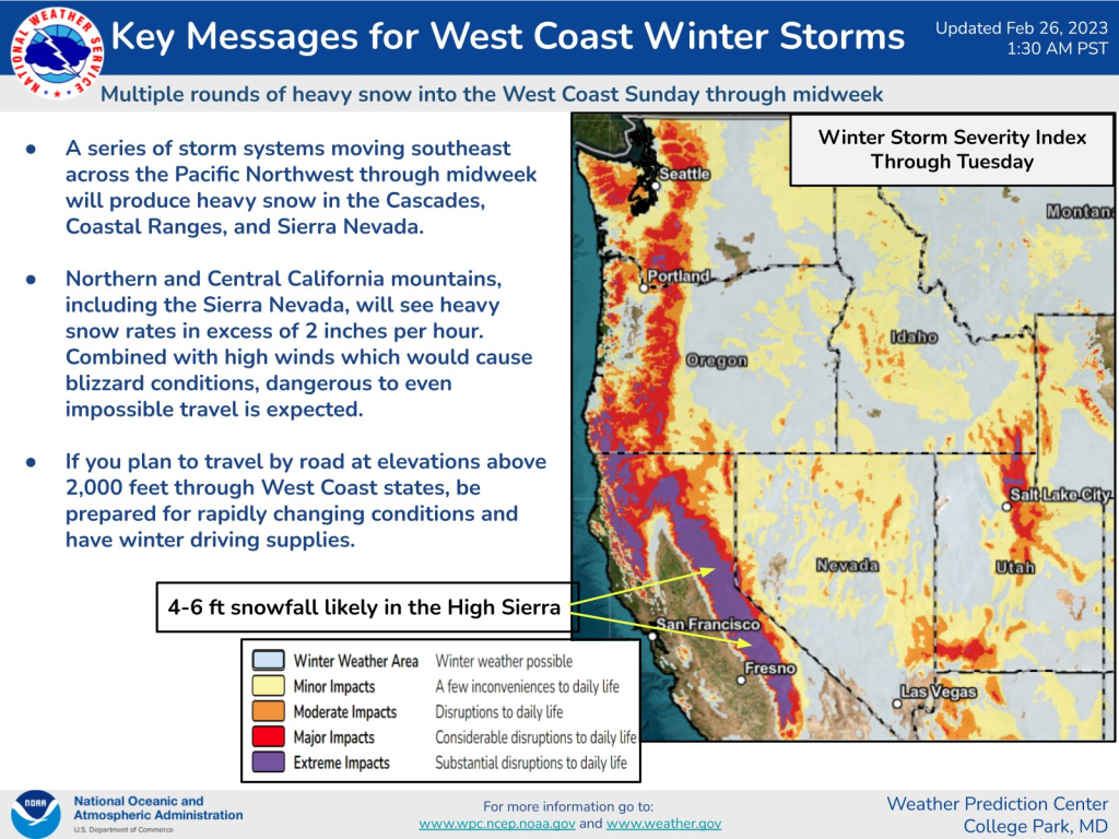
SNOHOMISH COUNTY, February 26, 2023—The National Weather Service has issued a Winter Weather Advisory until 10 a.m. Sunday, February 26 for Everett, Marysville, Mountlake Terrace, and Stanwood. Expect icy conditions and an additional inch of snow in the morning.
Rain and snow expected will result in icy conditions as overnight lows are expected to drop to below freezing every night this week. Cities throughout Snohomish County are expected to see temperatures fluctuate between a low of 28°F on Tuesday to a high of 47°F on Saturday. Caution is advised for morning commuters.


Rainy day? No problem…here are many indoor activities in the Lynnwood area to keep your spirits up!
Snohomish County Weather Feb 26 to Mar 3
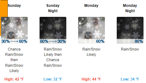
- Sunday (Feb 26): A chance of rain and snow showers before 1pm, then rain showers likely. Mostly cloudy, with a high near 42. South wind 6 to 11 mph becoming west northwest in the afternoon. Chance of precipitation is 60%. Little or no snow accumulation expected.
- Sunday Night: Rain and snow showers likely before 10pm, then a chance of snow showers between 10pm and 4am, then a chance of rain and snow showers after 4am. Mostly cloudy, with a low around 32. Southeast wind 5 to 8 mph. Chance of precipitation is 60%. New snow accumulation of less than a half inch possible.
- Monday (Feb 27): Rain and snow showers likely, becoming all rain after 1pm. Mostly cloudy, with a high near 44. Calm wind becoming east around 6 mph in the afternoon. Chance of precipitation is 60%. New snow accumulation of less than a half inch possible.
- Monday Night: Rain showers likely before 10pm, then snow showers, possibly mixed with rain. Low around 34. Calm wind becoming southeast 5 to 7 mph after midnight. Chance of precipitation is 80%. New snow accumulation of less than one inch possible.
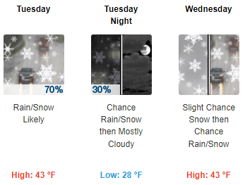
- Tuesday (Feb 28): Rain and snow showers likely before 7am, then snow showers likely between 7am and 10am, then rain and snow showers likely after 10am. Mostly cloudy, with a high near 43. Chance of precipitation is 70%. New snow accumulation of less than a half inch possible.
- Tuesday Night: A chance of rain and snow before 10pm. Mostly cloudy, with a low around 28. Chance of precipitation is 30%. Little or no snow accumulation expected.
- Wednesday (Mar 1): A slight chance of snow between 10am and 1pm, then a chance of rain and snow. Mostly cloudy, with a high near 43.
- Wednesday Night: Rain and snow likely, mainly after 10pm. Mostly cloudy, with a low around 35.
- Thursday (Mar 2): Rain. Cloudy, with a high near 44.
- Thursday Night: Rain and snow showers likely. Mostly cloudy, with a low around 34.
- Friday (Mar 3): A slight chance of snow. Partly sunny, with a high near 36.
- Friday Night: Rain and snow showers likely. Mostly cloudy, with a high near 45.
- Saturday (Mar 4): A chance of rain. Mostly cloudy, with a low around 32.
- Saturday Night: A chance of rain and snow. Mostly cloudy, with a high near 47.

Author: Lynnwood Times Staff