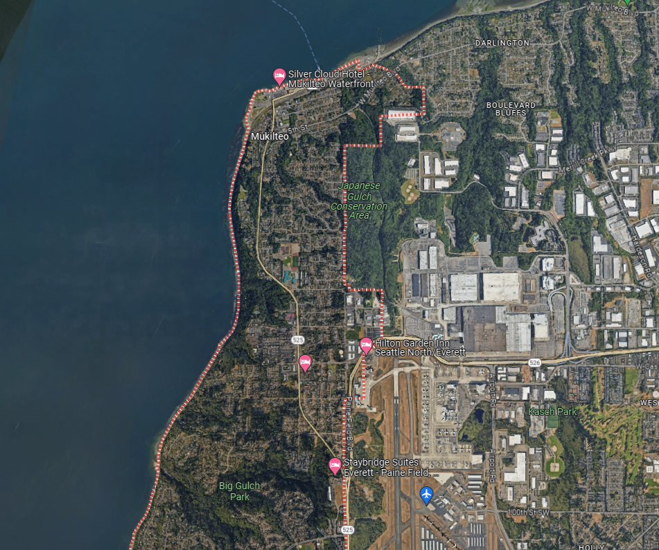
MUKILTEO—A Cessna 150 returning inbound to Paine Field Airport, crashed in a wooded ravine of Japanese Gulch, just south of the Mukilteo Dog Park around 5:26 p.m., Friday, February 16. The pilot, and only person aboard the single engine aircraft, survived and is in stable condition with no major injuries.

Mukilteo Fire Department, Snohomish County Sheriff, and Mukilteo Police responded to the incident after the pilot called 911. An all-terrain vehicle was used to locate the downed Cessna under heavy brush in a ravine of Japanese Gulch.


According to Flightradar24, the Cessna departed Paine Field Airport (PAE) at 3:57:48 p.m. heading west towards William R Fairfield International Airport (CLM) in Port Angeles in Clallam County. The aircraft reached a cruising altitude over Whidbey Island of 4,300 feet and then at 4:29:58 p.m. began its descent into CLM.
The aircraft appeared to have performed a touch-and-go landing (TGL) maneuver—this is when a plane approaches the runway, lands, then adds power and takeoffs immediately without coming to a full stop—at 4:38:23 p.m.; and by 4:39 p.m. the plane was back in the air heading in bound to PAE in Snohomish County.

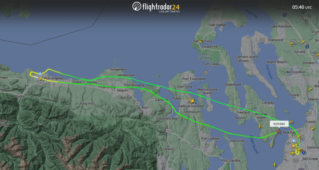
The Cessna 150, reached a cruising altitude of 3,400 feet at 4:44 p.m. At 5:16:22 p.m., just 10 minutes before the crash, the aircraft maintained an altitude of roughly 3,000 feet but began to accelerate from 70 knots (81 mph) to 87 knots (100 mph) over a duration of five minutes. At 5:22 p.m., flying south of Maxwelton in Whidbey Island, the plane began a gradual descent but further accelerated to 94 knots (108 mph) just 2 minutes before the crash.
At 8:24:54 p.m. at an altitude of 1,600 feet, the plane began to make its approach to runway 16R (Boeing Freeway) but was still over the waters of Possession Sound and north of Japanese Gulch. The plane rapidly descended to 400 feet by 5:26 p.m. at a speed of 64 knots (74 mph) when the transponder signal ended just south of Mukilteo Dog Park.
According to Google Maps, the Gulch is at an elevation of 400 feet above sea level with a peak of approximately 549 feet. The pilot avoided hitting any buildings and utilities.
A Cessna 150 is a “trainer” aircraft and was replaced by the 152 model in 1978. It is powered by a four cylinder, horizontally opposed, normally aspirated, direct drive, air-cooled, carburetor equipped engine with a 26-gallon fuel capacity (42 gallons if upgraded). The Cessna cruises at 121 mph and according to the Aircraft Owners and Pilots Association, more than a quarter-million pilots have trained on both the 150 and 152 models.
Developing story.
PHOTO CREDIT: Photo of Cessna 150 by John Davies from [https://commons.wikimedia.org/wiki/File:Cessna_150M_AN0931537.jpg commons.wikimedia] with UploadWizard

Author: Mario Lotmore